Tập tin:Kansai closeup.jpg
Giao diện
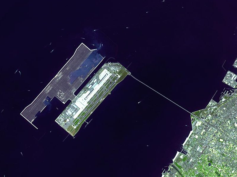
Kansai_closeup.jpg (800×600 điểm ảnh, kích thước tập tin: 66 kB, kiểu MIME: image/jpeg)
Lịch sử tập tin
Nhấn vào ngày/giờ để xem nội dung tập tin tại thời điểm đó.
| Ngày/giờ | Hình xem trước | Kích cỡ | Thành viên | Miêu tả | |
|---|---|---|---|---|---|
| hiện tại | 03:46, ngày 13 tháng 12 năm 2005 |  | 800×600 (66 kB) | Sam916~commonswiki | Satellite image of Kansai International Airport in Osaka Bay in Japan. This is a closeup - for an overview image showing the airport on its artificial island in the bay, see Image:Wfm kansai overview.jpg Taken from an uncopyrighted imag |
Trang sử dụng tập tin
Có 1 trang tại Wikipedia tiếng Việt có liên kết đến tập tin (không hiển thị trang ở các dự án khác):
Sử dụng tập tin toàn cục
Những wiki sau đang sử dụng tập tin này:
- Trang sử dụng tại ar.wikipedia.org
- Trang sử dụng tại ast.wikipedia.org
- Trang sử dụng tại bbc.wikipedia.org
- Trang sử dụng tại bg.wikipedia.org
- Trang sử dụng tại bh.wikipedia.org
- Trang sử dụng tại bn.wikipedia.org
- Trang sử dụng tại de.wikipedia.org
- Trang sử dụng tại el.wikipedia.org
- Trang sử dụng tại en.wikipedia.org
- Trang sử dụng tại en.wikibooks.org
- Trang sử dụng tại es.wikipedia.org
- Trang sử dụng tại eu.wikipedia.org
- Trang sử dụng tại fa.wikipedia.org
- Trang sử dụng tại fi.wikipedia.org
- Trang sử dụng tại he.wikipedia.org
- Trang sử dụng tại hu.wikipedia.org
- Trang sử dụng tại id.wikipedia.org
- Trang sử dụng tại io.wikipedia.org
- Trang sử dụng tại it.wikipedia.org
- Trang sử dụng tại it.wikivoyage.org
- Trang sử dụng tại ja.wikipedia.org
- Trang sử dụng tại ko.wikipedia.org
- Trang sử dụng tại lfn.wikipedia.org
- Trang sử dụng tại ml.wikipedia.org
- Trang sử dụng tại mn.wikipedia.org
- Trang sử dụng tại ms.wikipedia.org
- Trang sử dụng tại nl.wikipedia.org
- Trang sử dụng tại pt.wikipedia.org
- Trang sử dụng tại simple.wikipedia.org
- Trang sử dụng tại sl.wikipedia.org
- Trang sử dụng tại sr.wikipedia.org
- Trang sử dụng tại sv.wikipedia.org
- Trang sử dụng tại ta.wikipedia.org
- Trang sử dụng tại uk.wikipedia.org
- Trang sử dụng tại www.wikidata.org
- Trang sử dụng tại zh-yue.wikipedia.org
- Trang sử dụng tại zh.wikipedia.org


