
Tập tin:Map Denmark CIA extended.gif
Không có độ phân giải cao hơn.
Map_Denmark_CIA_extended.gif (300×347 điểm ảnh, kích thước tập tin: 16 kB, kiểu MIME: image/gif)
Tập tin này từ Wikimedia Commons. Trang miêu tả nó ở đấy được sao chép dưới đây. Commons là kho lưu trữ tập tin phương tiện có giấy phép tự do. Bạn có thể tham gia. |
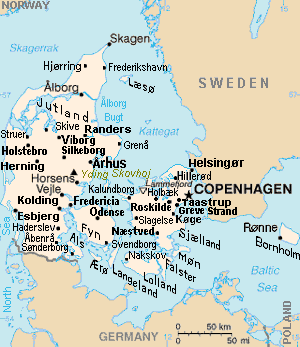
Miêu tả
| Miêu tả | Map of Denmark, showing largest cities and island/region names. Most city names (31) have been labeled with font-face Arial or Arial Narrow, as font-size 8 or 10; the island/region names are labeled on the diagonal at a 20-degree slant. Denmark contains over 300 towns, but they are evenly dispersed around 35 main towns, except near Copenhagen, which has very high density. |
| Ngày | |
| Nguồn gốc | Derivative of CIA map (Wikimedia Commons): Image:Denmark-CIA WFB Map.png (adding 25 labels, restoring color to CIA hues, and magnified 15%) |
| Tác giả | Wikid77 (derivative of CIA map, adding 25 labels) |
| Phiên bản khác |
This map has some variations:
|
Giấy phép
This image is in the public domain because it contains materials that originally came from the United States Central Intelligence Agency's World Factbook.
|
 |
Format

This file is purposely maintained in GIF format (most international GIF-related patents have expired) for compatibility with the original CIA maps. Semi-automatic conversions to PNG-format might lose the color hues of the CIA maps, tending to shift to lighter blue and shift beige to white. A larger, detailed version of the map is being expanded, with more of the smaller 300 towns added.
Lịch sử tập tin
Nhấn vào ngày/giờ để xem nội dung tập tin tại thời điểm đó.
| Ngày/giờ | Hình xem trước | Kích cỡ | Thành viên | Miêu tả | |
|---|---|---|---|---|---|
| hiện tại | 16:26, ngày 30 tháng 11 năm 2012 | | 300×347 (16 kB) | Ras67 | cropped |
| 13:51, ngày 4 tháng 9 năm 2007 |  | 300×350 (16 kB) | Wikid77 | relabeled "NORWAY"/"POLAND"; raised "Taastrup"/"Koge" near city-dots | |
| 15:41, ngày 3 tháng 9 năm 2007 |  | 300×350 (16 kB) | Wikid77 | added "Kalundborg" by lowering "Fredericia"/"Odense"/"Fyn" and lowered Copenhagen star, "Taastrup"/"Koge" and "Greve Strand" etc. | |
| 13:24, ngày 31 tháng 8 năm 2007 |  | 300×350 (16 kB) | Wikid77 | slashed 'o' 3x | |
| 06:04, ngày 29 tháng 8 năm 2007 |  | 300×350 (16 kB) | Wikid77 | {{Information | Description=Map of Denmark, showing largest cities and island/region names. | Source=Derivative of CIA map | Date=29-August-2007 | Author= Wikid77 (derivative of CIA map) | Permission=(see below) }} |
Trang sử dụng tập tin
Có 15 trang tại Wikipedia tiếng Việt có liên kết đến tập tin (không hiển thị trang ở các dự án khác):
Sử dụng tập tin toàn cục
Những wiki sau đang sử dụng tập tin này:
- Trang sử dụng tại ast.wikipedia.org
- Trang sử dụng tại ca.wikipedia.org
- Trang sử dụng tại es.wikipedia.org
- Trang sử dụng tại et.wikipedia.org
- Trang sử dụng tại fa.wikipedia.org
- Trang sử dụng tại gl.wikipedia.org
- Trang sử dụng tại hr.wikipedia.org
- Trang sử dụng tại ja.wikipedia.org
- Trang sử dụng tại kn.wikipedia.org
- Trang sử dụng tại ko.wikipedia.org
- Trang sử dụng tại mk.wikipedia.org
- Trang sử dụng tại ms.wikipedia.org
- Trang sử dụng tại pt.wikipedia.org
- Trang sử dụng tại th.wikipedia.org
- Trang sử dụng tại zh.wikipedia.org