
Tập tin:North Caucasus topographic map-fr.svg

Kích thước bản xem trước PNG này của tập tin SVG: 800×392 điểm ảnh. Độ phân giải khác: 320×157 điểm ảnh | 640×313 điểm ảnh | 1.024×501 điểm ảnh | 1.280×626 điểm ảnh | 2.560×1.253 điểm ảnh | 805×394 điểm ảnh.
Tập tin gốc (tập tin SVG, 805×394 điểm ảnh trên danh nghĩa, kích thước: 3,89 MB)
Tập tin này từ Wikimedia Commons. Trang miêu tả nó ở đấy được sao chép dưới đây. Commons là kho lưu trữ tập tin phương tiện có giấy phép tự do. Bạn có thể tham gia. |
Miêu tả
| Miêu tả |
|
| Ngày | |
| Nguồn gốc |
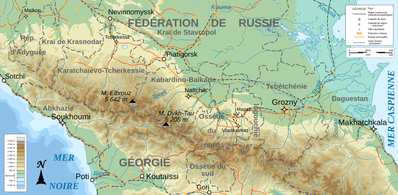
English: Own work ; Topographic data from the NASA Shuttle Radar Topography Mission (SRTM3 v.2) (public domain) edited with 3DEM, reprojected in UTM with GDAL (GDAL), and vectorized with Inkscape ; UTM projection ; WGS84 datum ; shaded relief (composite image of N-W, W and N lightning positions) ; Reference used for the additional data : * Rivers, cities, railroads, routes, bathymetry : Demis add-on for World Wind (see the approval e-mail and the Demis forum) ; * Borders and coast : World data bank II ; Approximate scale of topographic data : 1:1,463,000 ; Note : The shaded relief is a raster image embedded in the SVG file. Français : Création personnelle ; Données topographiques de la NASA Shuttle Radar Topography Mission (SRTM3 v.2) (domaine public) éditées avec 3DEM, reprojetées en UTM avec GDAL et vectorisées avec Inkscape ; projection UTM ; WGS84 datum ; relief ombré (image composite d'éclairages du N-O, O et N) ; Références utilisées pour les données complémentaires : * Rivières, villes, chemins de fers, routes, bathymétrie : Demis add-on for World Wind (cf. l'e-mail d'approbation de Demis et le Demis forum) ; * Frontières et côtes : World data bank II ; Note : Le relief ombré est une image bitmap embarquée dans le fichier SVG. |
| Tác giả | Bourrichon - fr:Bourrichon) |
| Giấy phép (Dùng lại tập tin) |
GFDL / Attribution and Share-Alike required |
| Phiên bản khác |
Derivative works of this file: North Caucasus topographic map-es.svg
|


|
Tập tin SVG này chứa văn bản nhúng có thể biên dịch sang ngôn ngữ của bạn, bằng cách dùng một trình chỉnh sửa hỗ trợ SVG (như XML hay văn bản). Để biết thêm thông tin, xem Về việc biên dịch tập tin SVG. |
Giấy phép
Tôi, người giữ bản quyền tác phẩm này, từ đây phát hành nó theo các giấy phép sau:

|
Bạn có quyền sao chép, phân phối và/hoặc sửa đổi tài liệu này theo những điều khoản được quy định trong Giấy phép Tài liệu Tự do GNU, phiên bản 1.2 hoặc các phiên bản mới hơn được Quỹ Phần mềm Tự do; quy định; ngoại trừ những phần không được sửa đổi, bìa trước và bìa sau. Bạn có thể xem giấy phép nói trên ở phần Giấy phép Tài liệu Tự do GNU. |
This file is licensed under the Creative Commons Attribution-Share Alike Attribution-Share Alike 4.0 International, 3.0 Unported, 2.5 Generic, 2.0 Generic and 1.0 Generic license.
- Bạn được phép:
- chia sẻ – sao chép, phân phối và chuyển giao tác phẩm
- pha trộn – để chuyển thể tác phẩm
- Theo các điều kiện sau:
- ghi công – Bạn phải ghi lại tác giả và nguồn, liên kết đến giấy phép, và các thay đổi đã được thực hiện, nếu có. Bạn có thể làm các điều trên bằng bất kỳ cách hợp lý nào, miễn sao không ám chỉ rằng người cho giấy phép ủng hộ bạn hay việc sử dụng của bạn.
- chia sẻ tương tự – Nếu bạn biến tấu, biến đổi, hoặc làm tác phẩm khác dựa trên tác phẩm này, bạn chỉ được phép phân phối tác phẩm mới theo giấy phép y hệt hoặc tương thích với tác phẩm gốc.
Bạn có thể chọn giấy phép mà bạn muốn.
Lịch sử tập tin
Nhấn vào ngày/giờ để xem nội dung tập tin tại thời điểm đó.
| Ngày/giờ | Hình xem trước | Kích cỡ | Thành viên | Miêu tả | |
|---|---|---|---|---|---|
| hiện tại | 00:13, ngày 15 tháng 2 năm 2023 | | 805×394 (3,89 MB) | Takhirgeran Umar | Reverted to version as of 21:08, 13 January 2020 (UTC) |
| 01:44, ngày 1 tháng 2 năm 2023 |  | 805×394 (3,89 MB) | Niyskho | Reverted to version as of 16:42, 8 November 2008 (UTC) | |
| 21:08, ngày 13 tháng 1 năm 2020 |  | 805×394 (3,89 MB) | Takhirgeran Umar | Clarification | |
| 17:27, ngày 9 tháng 11 năm 2008 |  | 805×394 (3,89 MB) | Bourrichon | ||
| 16:42, ngày 8 tháng 11 năm 2008 |  | 805×394 (3,89 MB) | Bourrichon | == Summary == {{Information |Description={{de|Topographische Karte von Nordkaukasus, französische Version}}{{en|Topographic map in French of North Caucasus}}{{fr|Carte topographique en français de la [[:fr:Cis |
Trang sử dụng tập tin
Có 1 trang tại Wikipedia tiếng Việt có liên kết đến tập tin (không hiển thị trang ở các dự án khác):
Sử dụng tập tin toàn cục
Những wiki sau đang sử dụng tập tin này:
- Trang sử dụng tại en.wikipedia.org
- Trang sử dụng tại en.wikinews.org
- Trang sử dụng tại fi.wikipedia.org
- Trang sử dụng tại fr.wikipedia.org
- Trang sử dụng tại incubator.wikimedia.org