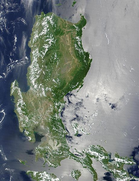
Tập tin:Northern Philippines (Luzon).jpg

Kích thước hình xem trước: 461×599 điểm ảnh. Độ phân giải khác: 184×240 điểm ảnh | 369×480 điểm ảnh | 591×768 điểm ảnh | 788×1.024 điểm ảnh | 2.000×2.600 điểm ảnh.
Tập tin gốc (2.000×2.600 điểm ảnh, kích thước tập tin: 738 kB, kiểu MIME: image/jpeg)
Lịch sử tập tin
Nhấn vào ngày/giờ để xem nội dung tập tin tại thời điểm đó.
| Ngày/giờ | Hình xem trước | Kích cỡ | Thành viên | Miêu tả | |
|---|---|---|---|---|---|
| hiện tại | 21:52, ngày 25 tháng 10 năm 2005 |  | 2.000×2.600 (738 kB) | Brian0918 | * Credit Jacques Descloitres, MODIS Land Rapid Response Team, NASA/GSFC This MODIS true-color image of the northern Philippines shows the island of Luzon and the Cagayan River running in the plains between the Sierra Madre mountain rang |
Trang sử dụng tập tin
Có 1 trang tại Wikipedia tiếng Việt có liên kết đến tập tin (không hiển thị trang ở các dự án khác):
Sử dụng tập tin toàn cục
Những wiki sau đang sử dụng tập tin này:
- Trang sử dụng tại af.wikipedia.org
- Trang sử dụng tại ar.wikipedia.org
- Trang sử dụng tại arz.wikipedia.org
- Trang sử dụng tại ast.wikipedia.org
- Trang sử dụng tại ba.wikipedia.org
- Trang sử dụng tại be-tarask.wikipedia.org
- Trang sử dụng tại be.wikipedia.org
- Trang sử dụng tại bg.wikipedia.org
- Trang sử dụng tại bjn.wikipedia.org
- Trang sử dụng tại bo.wikipedia.org
- Trang sử dụng tại ca.wikipedia.org
- Trang sử dụng tại cy.wikipedia.org
- Trang sử dụng tại de.wikipedia.org
- Trang sử dụng tại el.wikipedia.org
- Trang sử dụng tại en.wikipedia.org
- Trang sử dụng tại eo.wikipedia.org
- Trang sử dụng tại es.wikipedia.org
- Trang sử dụng tại et.wikipedia.org
- Trang sử dụng tại eu.wikipedia.org
- Trang sử dụng tại fa.wikipedia.org
- Trang sử dụng tại fi.wiktionary.org
- Trang sử dụng tại fr.wikipedia.org
- Trang sử dụng tại fr.wikivoyage.org
- Trang sử dụng tại ga.wikipedia.org
- Trang sử dụng tại he.wikipedia.org
- Trang sử dụng tại hu.wikipedia.org
- Trang sử dụng tại hy.wikipedia.org
- Trang sử dụng tại ia.wikipedia.org
- Trang sử dụng tại id.wikipedia.org
- Trang sử dụng tại id.wiktionary.org
- Trang sử dụng tại incubator.wikimedia.org
- Trang sử dụng tại jv.wikipedia.org
- Trang sử dụng tại ka.wikipedia.org
- Trang sử dụng tại ky.wikipedia.org
- Trang sử dụng tại lv.wikipedia.org
- Trang sử dụng tại ms.wikipedia.org
- Trang sử dụng tại nn.wikipedia.org
- Trang sử dụng tại os.wikipedia.org
- Trang sử dụng tại pl.wikipedia.org
Xem thêm các trang toàn cục sử dụng tập tin này.


