
Tập tin:Perspective view of truss span, looking NE. - Pennsylvania Railroad, West Brownsville Junction Bridge, Spanning Monongahela River, north of U.S. Route 40 Bridge, West Brownsville, HAER PA,63-BROVW,1-2.tif

Kích thước bản xem trước JPG này của tập tin TIF: 800×571 điểm ảnh. Độ phân giải khác: 320×228 điểm ảnh | 640×457 điểm ảnh | 1.024×731 điểm ảnh | 1.280×914 điểm ảnh | 2.560×1.827 điểm ảnh | 5.000×3.569 điểm ảnh.
Tập tin gốc (5.000×3.569 điểm ảnh, kích thước tập tin: 17,02 MB, kiểu MIME: image/tiff)
Tập tin này từ Wikimedia Commons. Trang miêu tả nó ở đấy được sao chép dưới đây. Commons là kho lưu trữ tập tin phương tiện có giấy phép tự do. Bạn có thể tham gia. |
| Perspective view of truss span, looking NE. - Pennsylvania Railroad, West Brownsville Junction Bridge, Spanning Monongahela River, north of U.S. Route 40 Bridge, West Brownsville, Washington County, PA | ||||
|---|---|---|---|---|
| Nhiếp ảnh gia |
Lowe, Jet, creator |
|||
| Tựa đề |
Perspective view of truss span, looking NE. - Pennsylvania Railroad, West Brownsville Junction Bridge, Spanning Monongahela River, north of U.S. Route 40 Bridge, West Brownsville, Washington County, PA |
|||
| Miêu tả |
Leonard, H R; Pennsylvania Steel Company; Lucius Engineering Company; Pennsylvania Railroad; Consolidated Rail Corporation (Conrail); Norfolk Southern Railroad; DeLony, Eric N, project manager; Pennsylvania Historical and Museum Commission, sponsor; Consolidated Rail Corporation (Conrail), sponsor; Spivey, Justin M, historian; Lowe, Jet, photographer |
|||
| Depicted place | Pennsylvania; Washington County; West Brownsville | |||
| Ngày | 1999 | |||
| Kích thước | 5 x 7 in. | |||
| Nơi đang treo |
Library of Congress Prints and Photographs Division Washington, D.C. 20540 USA http://hdl.loc.gov/loc.pnp/pp.print |
|||
| Số lưu trữ |
HAER PA,63-BROVW,1-2 |
|||
| Gốc gác tác phẩm |
|
|||
| Ghi chú |
|
|||
| Nguồn gốc | https://www.loc.gov/pictures/item/pa3769.photos.362296p | |||
| Giấy phép (Dùng lại tập tin) |
|
|||

Lịch sử tập tin
Nhấn vào ngày/giờ để xem nội dung tập tin tại thời điểm đó.
| Ngày/giờ | Hình xem trước | Kích cỡ | Thành viên | Miêu tả | |
|---|---|---|---|---|---|
| hiện tại | 05:59, ngày 1 tháng 8 năm 2014 | 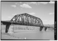 | 5.000×3.569 (17,02 MB) | Fæ | GWToolset: Creating mediafile for Fæ. HABS 31 July 2014 (3000:3200) |
Trang sử dụng tập tin
Có 1 trang tại Wikipedia tiếng Việt có liên kết đến tập tin (không hiển thị trang ở các dự án khác):
Sử dụng tập tin toàn cục
Những wiki sau đang sử dụng tập tin này:
- Trang sử dụng tại ceb.wikipedia.org
- Trang sử dụng tại ce.wikipedia.org
- Trang sử dụng tại cy.wikipedia.org
- Trang sử dụng tại en.wikipedia.org
- Trang sử dụng tại es.wikipedia.org
- Trang sử dụng tại eu.wikipedia.org
- Trang sử dụng tại fr.wikipedia.org
- Trang sử dụng tại ht.wikipedia.org
- Trang sử dụng tại it.wikipedia.org
- Trang sử dụng tại lld.wikipedia.org
- Trang sử dụng tại pt.wikipedia.org
- Trang sử dụng tại sr.wikipedia.org
- Trang sử dụng tại tt.wikipedia.org
- Trang sử dụng tại uk.wikipedia.org
- Trang sử dụng tại uz.wikipedia.org
- Trang sử dụng tại www.wikidata.org
- Trang sử dụng tại zh-min-nan.wikipedia.org