
Tập tin:TyphoonNesat2005.jpg

Tập tin gốc (5.600×7.200 điểm ảnh, kích thước tập tin: 6,11 MB, kiểu MIME: image/jpeg)
Tập tin này từ Wikimedia Commons. Trang miêu tả nó ở đấy được sao chép dưới đây. Commons là kho lưu trữ tập tin phương tiện có giấy phép tự do. Bạn có thể tham gia. |
Miêu tả
| Miêu tả |
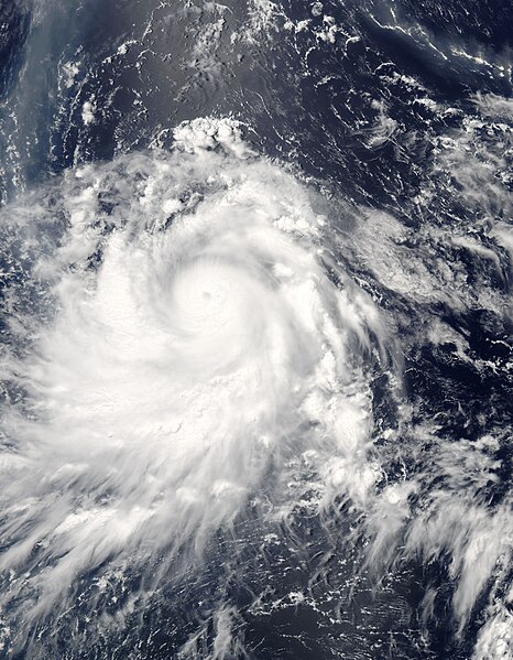
Typhoon Nesat spins over the Philippine Sea in this Moderate Resolution Imaging Spectroradiometer (MODIS) image acquired on June 3, 2005, by NASA’s Aqua satellite. At the time, Nesat had winds of 213 kilometers per hour (132 mph) with gusts to 259 kph (161 mph), making it the equivalent of a Category 4 hurricane. The storm formed near Guam on May 30 and moved slowly west northwest over the following four days. On June 3, Nesat skirted the Philippines as it curved northeast towards Japan. It is expected to miss the island nation as it moves east over the North Pacific. To the north of the typhoon, a white and brown plume of ash and steam drifts across the ocean from the Anatahan volcano. Located in the Northern Mariana Islands, just beyond the right edge of the image and immediately north of where Nesat formed, the volcano has been erupting for much of 2005. The ash plume cuts northwest across the upper right corner of the image, then curves sharply down across the upper left corner of the image. To the left of the center of the image, a silvery strip is formed by the reflection of the sun off the water’s surface. |
|||||
| Ngày | ||||||
| Nguồn gốc | http://visibleearth.nasa.gov/view_rec.php?id=6988 | |||||
| Tác giả | Jacques Descloitres, MODIS Rapid Response Team, NASA/GSFC | |||||
| Giấy phép (Dùng lại tập tin) |
|

Lịch sử tập tin
Nhấn vào ngày/giờ để xem nội dung tập tin tại thời điểm đó.
| Ngày/giờ | Hình xem trước | Kích cỡ | Thành viên | Miêu tả | |
|---|---|---|---|---|---|
| hiện tại | 15:06, ngày 6 tháng 9 năm 2006 | | 5.600×7.200 (6,11 MB) | Good kitty | higher res |
| 11:16, ngày 28 tháng 8 năm 2006 |  | 2.800×3.600 (2,1 MB) | Irfanfaiz | {{Information |Description=Typhoon Nesat spins over the Philippine Sea in this Moderate Resolution Imaging Spectroradiometer (MODIS) image acquired on June 3, 2005, by NASA’s [[w:Aqua (satellit |
Trang sử dụng tập tin
Sử dụng tập tin toàn cục
Những wiki sau đang sử dụng tập tin này:
- Trang sử dụng tại en.wikipedia.org
- Trang sử dụng tại es.wikipedia.org
- Trang sử dụng tại ja.wikipedia.org
- Trang sử dụng tại zh.wikipedia.org