
Tập tin:Bevölkerungsentwicklung Boitzenburger Land.pdf

Kích thước bản xem trước JPG này của tập tin PDF: 800×566 điểm ảnh. Độ phân giải khác: 320×226 điểm ảnh | 640×453 điểm ảnh | 1.024×724 điểm ảnh | 1.280×905 điểm ảnh | 1.752×1.239 điểm ảnh.
Tập tin gốc (1.752×1.239 điểm ảnh, kích thước tập tin: 122 kB, kiểu MIME: application/pdf)
Tập tin này từ Wikimedia Commons. Trang miêu tả nó ở đấy được sao chép dưới đây. Commons là kho lưu trữ tập tin phương tiện có giấy phép tự do. Bạn có thể tham gia. |
Miêu tả
| Miêu tả |
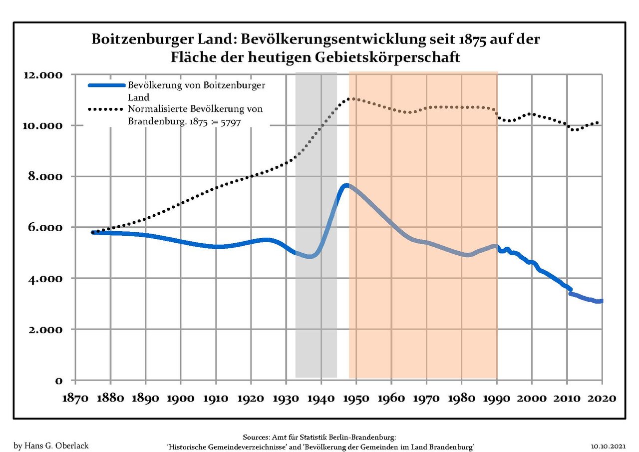
Deutsch: Grafik der Bevölkerungsentwicklung in den heutigen Grenzen von Boitzenburger Land, Landkreis Uckermark, Land Brandenburg, Deutschland
Blaue Linie: Bevölkerung -- Punktierte Linie: Vergleich mit der Entwicklung Brandenburgs Grauer Hintergrund: Zeit der Nazi-Herrschaft -- Roter Hintergrund: DDR-Zeit English: Chart of the population development within the current boundaries of Boitzenburger Land, Uckermark district, Brandenburg state, Germany
Blue line: Population -- Dotted line: Comparison to population development of Brandenburg state Grey background: Time of nazi rule -- Red background: Time of communist rule Español: Desarrollo de la población en los actuales límites de Boitzenburger Land, distrito de Uckermark, estado de Brandenburg, Alemania
Línea azul: Habitantes -- Línea de puntos: Comparación con el desarrollo de Brandenburgo Fondo gris: Período del gobierno nazi -- Fondo Rojo: Época communista Français : Évolution de la population dans les limites actuelles de Boitzenburger Land, arrondissement de Uckermark, Land de Brandebourg, Allemagne
Ligne bleue: Population -- Ligne pointillé: Comparaison avec le développement de Brandebourg Fond gris: Période du régime nazie -- Fond rouge: Période du régime communiste Italiano: Sviluppo della popolazione all'interno degli attuali confini di Boitzenburger Land , circondario di Uckermark, stato federato del Brandeburgo, Germania
Linea Blu: Popolazione -- Linea puntinata: Confronto dello sviluppo della popolazione dello stato del Brandenburgo Sfondo grigio: Ai tempi del governo nazista -- Sfondo rosso: Al tempo del governo comunista Nederlands: Ontwikkeling van de bevolking binnen de huidige grenzen van Boitzenburger Land, landkreis Uckermark, deelstaat Brandenburg, Duitsland
Blauwe lijn: Bevolking -- Stippellijn: Vergelijking van de ontwikkeling van de bevolking van de deelstaat Brandenburg Grijze achtergrond: tijdens de nazi-regering -- Rode achtergrond: tijdens de communistische regering Polski: Rozwój ludności w obecnych granicach dla Boitzenburger Land, powiat Uckermark, kraj Brandenburgia, Niemcy
Niebieska linia: Populacja -- Linia przerywana: Porównanie z rozwoju Brandenburgii Szare tło: Okres hitlerowców -- Czerwone tło: Okres rządów komunistycznych Svenska: Befolkningsutvecklingen i de nuvarande gränserna för Boitzenburger Land, landkreis Uckermark, delstaten Brandenburg, Tyskland Blå linje: Befolkning -- Prickade linjen: Jämförelse med utvecklingen av Brandenburg Grå bakgrund: Period av Nazi styre -- Röd bakgrund: Period av kommunistiskt styre |
| Ngày | giữa 13 tháng 10 năm 2012 và 10 tháng 10 năm 2021 |
| Nguồn gốc | Own work based on: Data sources displayed at Population Projection Brandenburg at Wikimedia Commons |
| Tác giả | Hans G. Oberlack |
| Latest population data | 2020 |
| Vị trí đối tượng | | Xem hình này và các hình ảnh lân cận trên: OpenStreetMap |
|---|
Giấy phép
Tôi, người giữ bản quyền tác phẩm này, từ đây phát hành nó theo giấy phép sau:
Tập tin này được phát hành theo Giấy phép Creative Commons Ghi công - Chia sẻ tương tự 3.0 Chưa chuyển đồi
- Bạn được phép:
- chia sẻ – sao chép, phân phối và chuyển giao tác phẩm
- pha trộn – để chuyển thể tác phẩm
- Theo các điều kiện sau:
- ghi công – Bạn phải ghi lại tác giả và nguồn, liên kết đến giấy phép, và các thay đổi đã được thực hiện, nếu có. Bạn có thể làm các điều trên bằng bất kỳ cách hợp lý nào, miễn sao không ám chỉ rằng người cho giấy phép ủng hộ bạn hay việc sử dụng của bạn.
- chia sẻ tương tự – Nếu bạn biến tấu, biến đổi, hoặc làm tác phẩm khác dựa trên tác phẩm này, bạn chỉ được phép phân phối tác phẩm mới theo giấy phép y hệt hoặc tương thích với tác phẩm gốc.
Lịch sử tập tin
Nhấn vào ngày/giờ để xem nội dung tập tin tại thời điểm đó.
| Ngày/giờ | Hình xem trước | Kích cỡ | Thành viên | Miêu tả | |
|---|---|---|---|---|---|
| hiện tại | 16:22, ngày 10 tháng 10 năm 2021 |  | 1.752×1.239 (122 kB) | Hans G. Oberlack | 2017, 2018, 2019, 2020 data added |
| 11:03, ngày 18 tháng 3 năm 2018 |  | 1.752×1.239 (119 kB) | Hans G. Oberlack | 2016 data added | |
| 10:00, ngày 28 tháng 10 năm 2017 |  | 1.752×1.239 (119 kB) | Hans G. Oberlack | 2015 data added | |
| 21:43, ngày 10 tháng 7 năm 2015 |  | 1.752×1.239 (97 kB) | Hans G. Oberlack | Graphics adjusted to recent data | |
| 11:58, ngày 13 tháng 10 năm 2012 |  | 1.752×1.239 (97 kB) | Hans G. Oberlack | User created page with UploadWizard |
Trang sử dụng tập tin
Có 1 trang tại Wikipedia tiếng Việt có liên kết đến tập tin (không hiển thị trang ở các dự án khác):
Sử dụng tập tin toàn cục
Những wiki sau đang sử dụng tập tin này:
- Trang sử dụng tại en.wikipedia.org
- Trang sử dụng tại es.wikipedia.org
- Trang sử dụng tại it.wikipedia.org
- Trang sử dụng tại ru.wikipedia.org