Thành viên:Geo-1852343/Nháp
| Đá Sa Thạch đỏ cổ Khoảng địa tầng: Kỷ nguyên cuối Silurian-Kỷ nguyên cacbon Carboniferous 419–358 triệu năm trước đây | |
|---|---|
 Folded Old Red Sandstone rock formation at St Annes Head in Pembrokeshire, Wales | |
| Kiểu | Supergroup |
| Sub-units | See text |
| Độ dày | More than 4 km (13.000 ft) (Shetlands) |
| Thạch học | |
| Nguyên sinh | Sandstone |
| Khác | Conglomerate, shale, mudstone, siltstone, limestone |
| Vị trí | |
| Khu vực | North Atlantic |
| Quốc gia | |
| Quy mô | 700 km (430 mi)[1] |
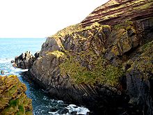
Đá Sa Thạch Đỏ Cổ[sửa | sửa mã nguồn]
' 'Đá sa thạch đỏ cổ' là tập hợp các khối đá ở khu vực Bắc Đại Tây Dương phần lớn có tuổi Devon. Nó nằm kéo dài ở phía đông trên khắp Vương quốc Anh, Ireland và Na Uy, và ở phía tây dọc theo bờ biển phía đông bắc của Bắc Mỹ. Nó cũng trải rộng về phía bắc vào Greenland và Svalbard.[3] Những khu vực này là một phần của lục địa cổ đại của Euramerica / Laurussia. Ở Anh, nó là một đơn vị [4]và có tầm quan trọng đáng kể đối với cổ sinh vật học. Thuận tiện hơn, phiên bản ngắn của thuật ngữ này, 'ORS' thường được sử dụng trong tài liệu về chủ đề này. Thuật ngữ này được đặt ra để phân biệt trình tự với Đá sa thạch đỏ mới cũng xuất hiện rộng rãi trên khắp nước Anh.
Trầm Tích[sửa | sửa mã nguồn]
Đá sa thạch đỏ cổ mô tả một bộ đá trầm tích thượng hạng lắng đọng trong nhiều môi trường khác nhau vào thời kỳ kỷ Devon nhưng kéo dài trở lại vào cuối kỷ Silurian và vào phần sớm nhất của kỷ cacbon. Cơ thể của đá hoặc tướng, bị chi phối bởi phù sa trầm tích và cuội kết tại cơ sở hạ tầng của nó, và tiến tới sự kết hợp của cồn, hồ và sông trầm tích. Màu đỏ quen thuộc của những tảng đá này phát sinh từ sự hiện diện của oxit sắt nhưng không phải tất cả Đá sa thạch đỏ cũ là đá đỏ hay đá sa thạch - chuỗi này cũng bao gồm các tập đoàn, đá bùn, đá silic và đá vôi mỏng và màu sắc có thể từ xám và xanh lục đến đỏ và màu tím. Các khoản tiền gửi này có liên quan chặt chẽ với sự xói mòn của chuỗi núi Caledonia, đã bị ném lên bởi sự va chạm của các lục địa cũ Avalonia, Baltica và Laurentia để tạo thành lục địa sa thạch đỏ cổ - một sự kiện được gọi là Orogen Caledonia. Many fossils are found within the rocks, including early fishes, arthropods and plants. As is typical with terrestrial red beds, the vast majority of the rock is unfossiliferous, however isolated, localized beds within the rock do contain fossils. Rocks of this age were also laid down in southwest England (hence the name 'Devonian'; from Devon) though these are of true marine origin and are not included within the Old Red Sandstone.[1]
Stratigraphy[sửa | sửa mã nguồn]
Since the Old Red Sandstone consists predominantly of rocks of terrestrial origin, it does not generally contain marine fossils which would otherwise prove useful in correlating one occurrence of the rock with another, both between and within individual sedimentary basins. Accordingly, local stage names were devised and these remain in use to some extent today though there is an increasing use of international stage names. Thus in the Anglo-Welsh Basin, there are frequent references to the Downtonian, Dittonian, Breconian and Farlovian stages in the literature. The existence of a number of distinct sedimentary basins throughout Britain has been established.[1]
Orcadian Basin[sửa | sửa mã nguồn]
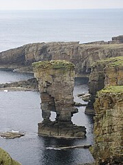
The Orcadian Basin extends over a wide area of North East Scotland and the neighbouring seas. It encompasses the Moray Firth and adjoining land areas, Caithness, Orkney and parts of Shetland. South of the Moray Firth, two distinct sub-basins are recognised at Turriff and at Rhynie. The sequence is more than 4 kilômét (13.000 ft) thick in parts of Shetland. The main basin is considered to be an intramontane basin resulting from crustal rifting associated with post-Caledonian extension, possibly accompanied by strike-slip faulting along the Great Glen Fault system.[5]
Argyll[sửa | sửa mã nguồn]
There are a scatter of exposures of the Old Red Sandstone around Oban and the Isle of Kerrera on the West Highland coast, this unit is sometimes referred to as the Kerrera Sandstone Formation. The unit is up to 128m thick in its type area and consists of green and red sandstones and conglomerates, typically containing large (10–30 cm hay 4–12 in across) elliptical well rounded clasts, accompanied by siltstones, mudstones and limestones.[6] On Kerrera a conglomerate of andesite boulders rests unconformably on Dalradian black, pyritic slates (Easdale Slate) of the Easdale Subgroup. On Oban there is merely an erosional contact incorporating debris of the slate in a basal conglomerate. The ORS around Oban are considered latest Silurian (Pridoli) to earliest Devonian in age. They are interpreted as alluvial fans which filled a depositional basin from the east and northeast.[7] Small outliers occur near Taynuilt and either side of Loch Avich.[8] The deposits are especially obvious on Kerrera where they form the bedrock across half of the island.[9] These are conformably overlain by peperite and the basaltic and andesitic Lorne plateau lavas. The ORS on Kerrera and isolated localities around Oban are known for their fossils, particularly fish.[10]
Midland Valley of Scotland[sửa | sửa mã nguồn]
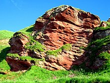
The Midland Valley graben defined by the Highland Boundary Fault in the north and the Southern Uplands Fault in the south harbours not only a considerable amount of Old Red Sandstone sedimentary rocks but also igneous rocks of this age associated with extensive volcanism. There is a continuous outcrop along the Highland Boundary Fault from Stonehaven on the North Sea coast to Helensburgh and beyond to Arran. A more disconnected series of outcrops occur along the line of the Southern Uplands Fault from Edinburgh to Girvan. Old Red Sandstone often occurs in conjunction with conglomerate formations, one such noteworthy cliffside exposure being the Fowlsheugh Nature Reserve, Kincardineshire.
Scottish borders[sửa | sửa mã nguồn]
A series of outcrops occur from East Lothian southwards through Berwickshire. Hutton's famous unconformity at Siccar Point occurs within this basin - see History of study below.
Anglo-Welsh Basin[sửa | sửa mã nguồn]
This relatively large basin extends across much of South Wales from southern Pembrokeshire in the west through Carmarthenshire into Powys and Monmouthshire and through the southern Welsh Marches, notably into Herefordshire, Worcestershire and Gloucestershire. Outliers in Somerset and north Devon complete the extent of this basin.
With the exception of south Pembrokeshire, all parts of the basin are represented by a range of lithologies assigned to the Lower Devonian and to the Upper Devonian, the contact between the two being unconformable and representing the complete omission of any Middle Devonian sequence. The lowermost formations are of upper Silurian age, these being the Downton Castle Sandstone Formation and the overlying Raglan Mudstone Formation except in Pembrokeshire where a more complex series of formations is recognised. In the east of the basin, the top of the Raglan Mudstone is marked by a well-developed calcrete, the Bishop's Frome Limestone.[11] The lowermost Devonian formation is the St Maughans Formation, itself overlain by the Brownstones Formation though with an intervening Senni Formation over much of the area. The Upper Devonian sequence is rather thinner and comprises a series of formations which are more laterally restricted. In the Brecon Beacons, the Plateau Beds Formation is unconformably overlain by the Grey Grits Formation though further east these divisions are replaced by the Quartz Conglomerate Group which is itself subdivided into a variety of different formations.
Pembrokeshire[sửa | sửa mã nguồn]
The sequence in Pembrokeshire differs from that of the main part of the basin and falls into two parts.[12]
In North Pembrokeshire to the north of the Ritec Fault, both the middle and upper ORS are missing with only the lower ORS present; this is divided into an earlier Milford Haven Group comprising in ascending order, the Red Cliff, Sandy Haven and Gelliswick Bay formations and a later Cosheston Group with, again in ascending order, its constituent Llanstadwell, Burton Cliff, Mill Bay, Lawrenny Cliff and New Shipping formations. These respectively equate with the Temeside, Raglan Mudstone and St Maughans formations of the central and eastern part of the basin.
- - middle and upper ORS missing -
- Cosheston Group
- Milford Haven Group
- Gelliswick Bay Formation
- Sandy Haven Formation (inc. Townsend Tuff Beds)
- Albion Sands Formation / Lindsway Bay Formation
- Red Cliff Formation
In south Pembrokeshire to the south of the Ritec Fault, the lower ORS is represented by, in ascending order, the Freshwater East, Moors Cliff and Freshwater West formations. These are unconformably overlain by the Ridgeway Conglomerate Formation. The middle ORS is missing whilst the Upper ORS is represented by the Gupton and West Angle formations.
- Skrinkle Sandstone Group
- - part of middle ORS missing -
- Ridgeway Conglomerate Formation
- - part of middle ORS missing -
- Milford Haven Group
- Freshwater West Formation (inc. Rat Island Mudstone Member and Conigar Pit Sandstone Member)
- Moor Cliffs Formation (inc. Chapel point calcretes member and Townsend Tuff Bed)
- Freshwater East Formation
The Freshwater East Formation, and corresponding Red Cliff Formation of north Pembrokeshire, are both late Silurian in age.[13]
Anglesey[sửa | sửa mã nguồn]
A small and separate basin exists here where both alluvial and lacustrine deposits are recorded. Both the middle and upper ORS are missing but the lower ORS is represented, in ascending order, by the Bodafon, Traeth Bach, Porth y Mor and Traeth Lligwy formations. Calcretes are also recorded representing carbonate-rich soils developed between periods of sediment deposition. The present day outcrop occupies a narrow zone from Dulas Bay on Anglesey's northeast coast, southwards to the town of Llangefni.[1][14]
History of study[sửa | sửa mã nguồn]
In 1787 James Hutton noted what is now known as Hutton's Unconformity at Inchbonny, Jedburgh, and in early 1788 he set off with John Playfair to the Berwickshire coast and found more examples of this sequence in the valleys of the Tower and Pease Burns near Cockburnspath.[15] They then took a boat trip from Dunglass Burn east along the coast with the geologist Sir James Hall of Dunglass and at Siccar Point found what Hutton called "a beautiful picture of this junction washed bare by the sea",[16] where 345-million-year-old Old Red Sandstone overlies 425-million-year-old Silurian greywacke.[2][17]
In the early 19th century, the paleontology of the formation was studied intensively by Hugh Miller, Henry Thomas De la Beche, Roderick Murchison, and Adam Sedgwick—Sedgwick's interpretation was the one that placed it in the Devonian: he coined the name of that period. The term 'Old Red Sandstone' was originally used in 1821 by Scottish naturalist and mineralogist Robert Jameson to refer to the red rocks which underlay the 'Mountain Limestone' i.e. the Carboniferous Limestone. They were thought at that time to be the British version of Germany's Rotliegendes, which is in fact of Permian age.[1] Many of the science of stratigraphy's early debates were about the Old Red Sandstone.
In older geological works predating theories of plate tectonics, the United States' Catskill Delta formation is sometimes referred to as part of the Old Red Sandstone. In the modern day it is recognized that the two are not stratigraphically continuous but are very similar due to being formed at approximately the same time by the same processes.
Use as a building stone[sửa | sửa mã nguồn]
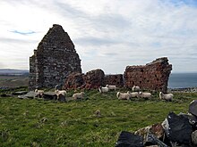
The Old Red Sandstone has been widely used as a building stone across those regions where it outcrops. Notable examples of its use can be found in the area surrounding Stirling,[18] Stonehaven,[19] Perth[20] and Tayside. The inhabitants of Caithness[21] at the northeastern tip of Scotland also used the stone to a considerable extent. Old Red Sandstone has also frequently been used in buildings in Herefordshire, Monmouthshire and the former Brecknockshire (now south Powys) of south Wales.
Notable buildings[sửa | sửa mã nguồn]
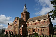
- Canada
- England
- Goodrich Castle, Herefordshire[22]
- Ross-on-Wye market hall, Herefordshire [1]
- Shrewsbury Castle, Shropshire [2]
- Hereford Cathedral, Herefordshire
- Scotland
- Arbroath Abbey, Angus
- Muchalls Castle, Aberdeenshire [3]
- St Magnus Cathedral, Orkney[23]
- Stonehaven Tolbooth, Aberdeenshire [4]
- Wales
- Raglan Castle, Monmouthshire[22]
- Tintern Abbey, Monmouthshire [5] and [6][22]
- Brecon Cathedral, Powys
See also[sửa | sửa mã nguồn]
References[sửa | sửa mã nguồn]
- ^ a b c d e Barclay, W.J. (2005). The Old Red Sandstone of Great Britain. City: Joint Nature Conservation Committee (JNCC). ISBN 978-1-86107-543-7.
- ^ a b Cliff Ford (2 tháng 9 năm 2003). “Siccar Point”. Field Excursion Preview. University of Edinburgh School of GeoSciences. Truy cập ngày 20 tháng 10 năm 2008.
- ^ Friend, P.F. and Williams, B.P.J. (eds) 2000 New Perspectives on the Old Red Sandstone. Geological Society, London, Special publications 180 p1,35
- ^ http://www.bgs.ac.uk/Lexicon/lexicon.cfm?pub=ORS entry in BGS on-line rock lexicon
- ^ Seranne, M. (1992). “Devonian extensional tectonics versus Carboniferous inversion in the northern Orcadian basin”. Journal of the Geological Society. 149 (1): 27–37. CiteSeerX 10.1.1.464.5569. doi:10.1144/gsjgs.149.1.0027. Truy cập ngày 25 tháng 2 năm 2010.
- ^ “Kerrera Sandstone Formation”. BGS Lexicon of Named Rock Units. British Geological Survey. Truy cập ngày 31 tháng 10 năm 2018.
- ^ British Geological Survey 1:50,000 scale geological map sheet 45W (Scotland) Connel 1991
- ^ British Geological Survey 1:50,000 scale geological map sheet 37W (Scotland) Furnace 2008
- ^ British Geological Survey 1:50,000 scale geological map sheet 44E (Scotland) Lismore 1992
- ^ Trewin, N. H.; Gurr, P. R.; Jones, R. B.; Gavin, P. (tháng 11 năm 2012). “The biota, depositional environment and age of the Old Red Sandstone of the island of Kerrera, Scotland”. Scottish Journal of Geology (bằng tiếng Anh). 48 (2): 77–90. doi:10.1144/sjg2012-452. ISSN 0036-9276.
- ^ http://www.bgs.ac.uk/lexicon/lexicon.cfm?pub=BFLS
- ^ Barclay, W.J. (2005) in The Old Red Sandstone of Great Britain (w.J. Barclay, M.A.E. Browne, A.A. McMillan, E.A. Pickett, P. Stone and P.R.Wilby) Geological Conservation Review series, No 31 JNCC, Peterborough pp 212-213
- ^ Howells, M.F. 2007 British Regional Geology: Wales (Keyworth, Nottingham. British Geological Survey) p100-101
- ^ British Geological Survey 1:50K special map sheet Anglesey
- ^ Keith Montgomery (2003). “Siccar Point and Teaching the History of Geology” (PDF). University of Wisconsin. Truy cập ngày 26 tháng 3 năm 2008.
- ^ “Hutton's Journeys to Prove his Theory”. Bản gốc lưu trữ ngày 26 tháng 7 năm 2011. Truy cập ngày 14 tháng 12 năm 2018.
- ^ Rance, Hugh (1999). “Hutton's unconformities” (PDF). Historical Geology: The Present is the Key to the Past. QCC Press. Bản gốc (PDF) lưu trữ ngày 3 tháng 12 năm 2008. Truy cập ngày 20 tháng 10 năm 2008.
- ^ https://www.geograph.org.uk/photo/271357
- ^ https://www.geograph.org.uk/photo/257397
- ^ https://www.geograph.org.uk/photo/12129
- ^ https://www.geograph.org.uk/photo/1064
- ^ a b c http://www.museumwales.ac.uk/media/4/9/5/2/Newsletter_5.pdf[liên kết hỏng]
- ^ BBC. “The Cathedrals of Britain”. Truy cập ngày 4 tháng 3 năm 2010.
External links[sửa | sửa mã nguồn]
| Wikimedia Commons có thêm hình ảnh và phương tiện truyền tải về Geo-1852343/Nháp. |
- Geological groups
- Geologic formations of Canada
- Geologic formations of Greenland
- Geologic formations of Ireland
- Geologic formations of Norway
- Geologic formations of the United Kingdom
- Geologic formations of the United States
- Carboniferous paleontological sites
- Carboniferous System of Europe
- Devonian System of Europe
- Silurian System of North America
- Devonian System of North America
- Carboniferous System of North America
- Silurian paleontological sites
- Devonian Canada
- Devonian England
- Devonian Ireland
- Devonian Greenland
- Devonian Norway
- Devonian Scotland
- Devonian United Kingdom
- Devonian United States
- Silurian Canada
- Silurian England
- Silurian Ireland
- Silurian Greenland
- Silurian Norway
- Silurian Scotland
- Silurian United Kingdom
- Silurian United States
- Carboniferous England
- Carboniferous Norway
- Carboniferous Scotland
- Carboniferous United Kingdom
- Sandstone formations
- Conglomerate formations
- Limestone formations
- Mudstone formations
- Shale formations
- Siltstone formations
- Geologic formations with imbedded sand dunes
- Aeolian deposits
- Fluvial deposits
- Lacustrine deposits
- Fossiliferous stratigraphic units of Europe
- Fossiliferous stratigraphic units of North America
- Paleontology in Canada
- Paleontology in England
- Paleontology in Ireland
- Paleontology in Greenland
- Paleontology in Norway
- Paleontology in the United Kingdom
- Paleontology in the United States
